
VIDEO: Trolley Blue Line expansion opens, officials grapple with a vision for the future
Elected officials approved a $160B plan for transit expansion, setting sights on making public transportation free within 10 years
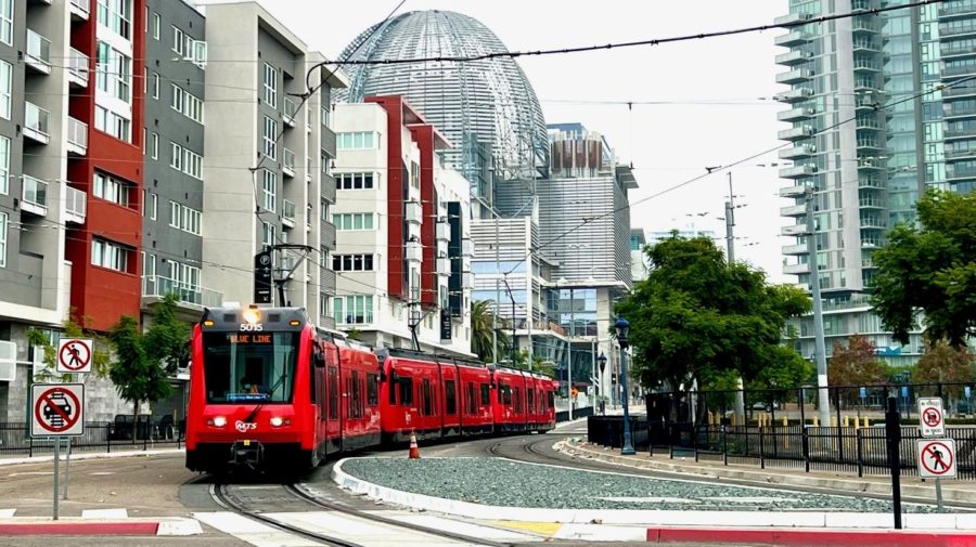
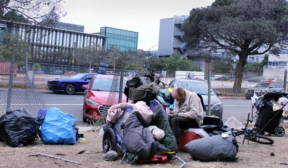
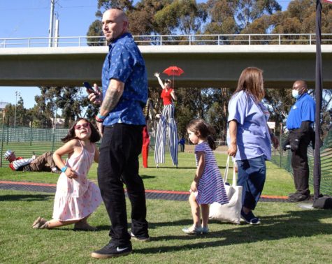
The San Diego Trolley UCSD Blue Line coasts by the Central Library. The Blue Line extension connects City College with all three major universities by light rail, and connects San Ysidro directly to University Town Center in La Jolla. Photo by Philip Salata/City Times Media
December 28, 2021
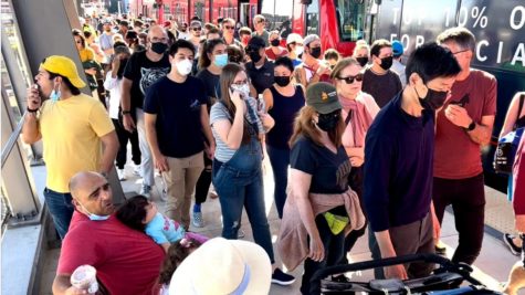
When the train jolted to a sudden stop, a domino of passengers lunged for whatever they could grab.
Though the driver avoided collision with one of the 8,500 pedestrians milling toward the grand opening of the new trolley line, a man in a wheelchair was hurled out of his seat.
Some dove to raise him up, while others argued with the family occupying the courtesy seating.
Before arriving to the free hot dogs and festivities, the constituents would have to undergo some practice in public interaction. Though some riders use the trolley regularly, for many it was a trial run.
The first attempt to build a rail line from downtown San Diego to La Jolla washed away in 1916, a year after the city council allotted rainmaker Charles Hatfield $10,000 to reverse several years of drought.
Hatfield earned the title by allegedly making it rain for some ranchers in La Crescenta, in northern Los Angeles County. The weather bureau linked his success to a small storm system passing through, but this did not thwart his believers.
Hatfield’s job was to build a tower and evaporate a brew of chemicals into the air to induce rain and fill the Morena Dam Reservoir.
And that is exactly what happened – so much so, two dams overflowed and 20 people perished.
The foundations for the prototypical “La Jolla line” were abandoned in the flooding.
The inauguration of the San Diego Trolley Mid-Coast Extension of the UC Blue Line to La Jolla is not only a major infrastructure development for the city’s transit system, but also a project with a history that spans well beyond the life of the entire Metropolitan Transit System.
It’s also a reminder of the city’s historically fraught relationship with climate and the local implication of geopolitics.
In, “Under the Perfect Sun,” an alternative history of San Diego, historian Mike Davis reminds us that, “in the case of San Diego, the local power struggles of the 1900’s, not surprisingly, were subsidiaries of more far-reaching regional and national conflicts.”
One of those was the race to connect the nation by rail.
Since its founding, San Diego has sparred with Los Angeles for prominence on the West Coast. San Diego’s expansion was always fraught with a lack of oil, little groundwater, drought and floods.
And when J.D. Spreckles’ San Diego-Arizona railway finally went defunct due to numerous fires, floods and earthquakes, the city was rendered the cul-de-sac of Southern California.
Yet recent developments in city planning show San Diego is vying to be “back on the map.”
On Nov. 9, in a joint bid, San Diego and Tijuana were named the World Design Capital of 2024 by the World Design Organization. They beat out runner-up Moscow.
It was the first collaboration of its kind to achieve the recognition, and will bring a series of events, projects, and design showcases in the coming years.
But after decades of suburban expansion, and in turn a dependence on cars, the region still needs ample development in the race to create adequate, equitable and sustainable public transit.
With the addition of the UC San Diego Blue Line, San Diego City College is now connected to all three major San Diego universities by light rail. And in turn, the San Diego Trolley connects San Ysidro and its U.S. Mexico port of entry with La Jolla.
For a commuter campus such as City, with its student population distributed widely throughout the county, this is a major piece of a still-unresolved puzzle.
Just two weeks after the opening of the Blue Line, the San Diego Association of Governments, or SANDAG, saw elected officials provisionally approve their $160 billion transportation plan for 2050.
The plan includes a goal of making public transportation free within ten years. The remaining sticking point, which has been met with much public disapproval, is a per-mile driving tax originally considered as a means for funding the plan.
SANDAG aims to build 200 miles of elevated and tunneled rail lines, including an electric high-speed commuter train traveling twice as fast as the trolley. The plan hinges on the building of a major transportation hub in San Ysidro as well as a central mobility hub near Lindbergh Field.
The city is negotiating with the U.S. Navy for its potential location that until now has been used by the Naval Information Warfare Systems Command (NAVWAR). SANDAG is also considering a downtown site that includes the current home of City Hall.
As San Diego officials move to densify and connect the city’s future landscape, there are both big ideas at play and potentially stifling challenges, such as the pace and cost of building and land-use disputes.
City College urban geography professor Lisa Chaddock expressed excitement and optimism at the prospects proposed by the opening of the Blue Line, as well as Mayor Todd Gloria’s drafting of a Climate Action Plan.
She also spoke to the obstacles of the proposed Central Mobility hub site.
“When you want to build on a place like that, first you get an environmental impact report,” Chaddock said. “And since the Navy was there, you have to check the soil and see if there’s any, how do I put this, anything toxic that shouldn’t be there leftover from World War II.”
Because of the location of the site, Chaddock advised that even if it is clear of toxic substances, city officials will have to mitigate for sea level rising.
She added that the San Diego Convention Center already has had to pump water from its parking lots since 2012 due to rising sea levels.
The transportation plan for 2050 marks a new direction in methods used to generate ideas for the expansion of mass transit – namely the use of data analytics, which had not yet been employed in the creation of the Blue Line.
This is a major conceptual shift in how urban and transportation planning will be carried out.
SANDAG’s Chief Analytics Officer Ray Major explained to City Times that, “this time, what we did is we put aside all of the assumptions we had with plans, and we said, let’s let data drive us in terms of where to go.”
“We started using not only data that was available to us from typical data sources, like the census,” he said. “We started using cell phone data, to be able to figure out where people begin trips and where they end trips. And so now all of a sudden, we’ve got big data that’s also involved in helping us do this planning.”
Major underscored that the cell phone data used was given voluntarily. According to Major, the data has helped SANDAG more precisely identify work hubs.
Most importantly, planners are now able to understand not only where congestion occurs, but where people are coming from and going to, which provides the engineers with more variables to troubleshoot.
The details make up the plan
A particular challenge in building user-friendly transportation in San Diego stems from suburbanization, which usually results in building horizontally rather than vertically.
Within the last 20 years, Major explained, SANDAG has shifted toward increasing urban density as a way of promoting connectivity.
Major said the organization is cognizant that integrating bicycles and bicycle lanes into the urban fabric is a way to work with existing infrastructure.
New lanes are appearing, though with the recent deaths of cyclists on Pershing Drive and Camino del Rio South, safety remains a concern.
Moreover, some trolley stations are located in hard-to-reach areas.
In a letter to Councilmember Jennifer Campbell, UCSD professor Dr. Matthew Vitz, a proponent of the extension, described his pedestrian journey on his first attempt to use the trolley to commute to work.
“Part of the problem has to do with the geography of the area,” Vitz wrote. “While I live no more than 1/2 mile from the stop as the crow flies, I will have to take a circuitous bike route to arrive at the station, or a long walk.”
While trying to cross the pedestrian bridge over Interstate 5, Vitz found there to be no crosswalk on Kettner Boulevard and India Street, the two thoroughfares that hug the highway.
This area, which is on the boundary between an industrial zone and a residential neighborhood, has limited lighting. Vitz had two near-misses with oncoming cars.
“This was the scariest pedestrian experience I have had in my seven-plus years of living in this city,” Vitz wrote.
In response, Council Representative Benny Cartwright wrote that Vitz’s concern had already been raised by another constituent and was forwarded to the Department of Traffic Engineering.
Improvements are in a “design phase.”
Examples such as this one suggest the potential for creating more public platforms in order to ensure that future plans meet not only macro-scale goals, but the daily needs of constituents.